Major Highlights of Everest Base Camp Trek By Helicopter Return
- Exploring the rich culture and ancient traditions of the Kathmandu Valley.
- Travelling together as a family, led by our experienced team and support crew.
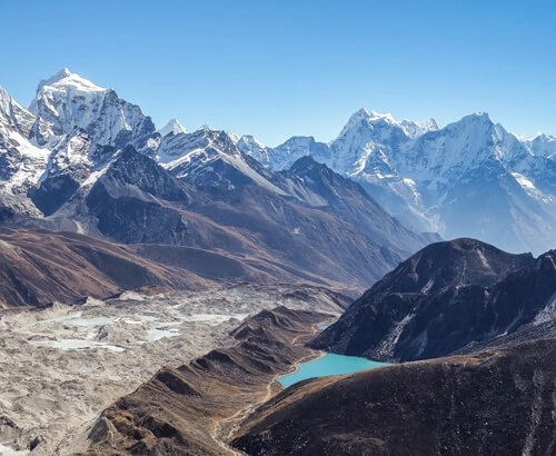
- Admiring the natural beauty of peaks such as Mt. Everest, Mt. Lhotse, and Mt. Cho Oyu.
- Immersing yourself in the stories and legends of the Himalayas, as shared by the Sherpas.
- Taking part in trade at Namche Bazaar, an important trading centre for the Sherpa community.
- Savouring the comforts and delicious food provided by top-quality hotels and lodges.
- Feel the excitement and sense of achievement as you climb towards the base camp.
- Enjoying exceptional flight experiences, including the flight to Lukla and the helicopter ride back from Kala Patthar.
Trekking and Helicopter Return Route
Many trekkers from around the world dream of trekking to the Everest region. They visualize walking through beautiful Sherpa villages, savoring delicious Nepali dishes, and even reaching Everest Base Camp - an incredible adventure. Luckily, the Everest Base Camp Helicopter Return Trek map and itinerary are here to make this classic experience more accessible.
The trek to Everest begins in Lukla and takes you north to Namche Bazaar. The trail then turns northeast, leading you to Namche Bazaar, Debouche, Dingboche, Lobuche, Gorak Shep, Everest Base Camp, and Kala Patthar. From Kala Patthar, you take a helicopter ride back to Kathmandu. Each day, you'll hike for a moderate 4-6 hours.
The path can be challenging, with rocky and rugged terrain as you progress from Lobuche at 4,940 metres to Gorak Shep at 5,164 metres. Moreover, maintaining a steady pace as you ascend to Kala Patthar at 5,500 metres can be quite strenuous. The changing altitude can affect your body, and you'll start to feel its effects.
We strongly advise you to check out the Everest trek map to learn about the altitude changes you'll encounter. This will help you prepare for the steep climb to higher elevations. The trek covers 130 kilometres, so staying physically fit is crucial to tackling challenges. Overcoming these difficulties is what adds excitement to the trek.
The Everest Base Camp Trek with Helicopter Return offers a fantastic way to enhance your trekking experience. Instead of walking the same path back, you can hop on a helicopter at Gorak Shep right after descending from Kala Patthar. This saves you from the tiring return journey and treats you to a breathtaking helicopter ride. Moreover, it helps avoid potential flight delays or cancellations at Lukla airport.
By doing this, you cut your return trip in half, meaning you don't have to cover the 65-kilometre journey back on foot after trekking 65 kilometres to reach the base camp. This makes the entire journey much more enjoyable and keeps things exciting.
Furthermore, if you're short on time and have limited vacation days, the 12-day Everest Base Camp Trek and Return by Helicopter is an excellent choice. It allows you to experience the wonders of Everest without the need for an extensive holiday.


Altitude Map For EBC trek By Helicopter Return
Your Everest base camp and return by helicopter start as soon as you land in Kathmandu at 1,400 m. At This altitude, do not post any AMS-related issues, so you are safe in Kathmandu. The next day, you drove towards Lukla via a 45-minute flight from Kathmandu. Lukla serves as the starting point for your amazing journey to Mount Everest. This picturesque village sits at an elevation of 2800 metres, which means it's quite common to feel the early signs of altitude sickness as you begin your trek. You'll resume your journey from here to the stunning foothills of the world's tallest mountain. Along the way, you'll stop at different places for overnight stays. This incredible trek through the serene Everest region typically lasts about 12 days.
From Lukla, you hike towards Namche Bazaar at 3438 m, Debuche, Dingboche (4,360 m), Lobuche (4,940 m) , Gorak Shep (5180 m), Kala Patthar elevation ( 5,545 m). This location may pose some high-altitude risks, so acclimatisation days are necessary. Our return journey will be the most comfortable for all as you will fly directly from kala author to Kathmandu in a sha.red or private helicopter.
Throughout most of the trek, you'll be hiking at altitudes over 3000 metres, so acclimatisation is important. However, other hiking options exist in the Everest region, such as the 3-pass trek, Everest Base Camp (EBC), and Gokyo Lake. The altitude gained, the symptoms, the duration, and the length of the trek depend on the specific trekking packages you choose.
If you're seeking a more comfortable trek with better accommodations, acclimatisation plans, and ample opportunities to explore the Khumbu region, you might consider the Ultimate Luxury EBC Trek plan. This alternative route takes you through mountain passes and high-elevation terrain in the Everest region, offering an adventurous and luxurious experience.
In this section, we've provided information about the elevation gain you'll experience at key locations along your trek.
Places | Altitude in Meter |
Kathmandu | (1,400m / 4,593ft) |
Lukla | (2,850m / 9,350ft) |
Phakding | ( 2,650m / 8,562ft ) |
Namche Bazaar | (3,440m / 11,285ft) |
Debouche | (3,855m / 12,850ft) |
Dingboche | (4,360m / 14,290ft) |
Lobuche | (4,930m / 16,175ft) |
Gorak Shep | (5,185m / 17,010ft) |
Kala Patthar | (5,555m / 18,208ft) |
Everest Base Camp | 5,364m (17,599ft) |
Places along During the Everest base Camp Trek By Helicopter Return
You'll see many cosy tea houses along the trail as you trek from Lukla. The path gradually climbs upwards, leading you to the well-known Namche Bazaar at an elevation of 3,438 metres. Moving forward, you'll pass through Phakding at 2,610 metres and Monjo at 2,835 metres. Then, you'll hike toward the entrance of Sagarmatha National Park, where you'll reach the Jorsale checkpoint.
During this part of the journey, you'll have the opportunity to enjoy stunning views of the Thamserku mountain at 6,623 metres, Kangtega at 6,782 metres, and the magnificent Ama Dablam at 6,812 metres. This scenic trail takes you from Monjo at 2,835 metres to Tengboche at 3,860 metres.
As you continue, the trail becomes steeper as you pass through Pangboche at 3,985 metres, eventually leading you to Pheriche at 4,371 metres or Dingboche at 4,410 metres. From this point, you'll trek for about six hours, eventually arriving at the beautiful lateral moraine of the Khumbu glacier at Lobuche, which is situated at 4,940 metres.
The final part of your trek will take you through the last settlement at Gorak Shep, at an elevation of 5,164 metres. From there, you'll journey over the glacier to reach Base camp of the world’s tallest mountain.
Once you've reached the camp’s summit, prepare for a breathtaking sight of the Khumbu Icefall. Following that, your journey takes you back to Gorak Shep for an overnight stay. The next day, you'll climb steeply to the highest point on your trek, Kala Patthar, standing tall at 5,500 metres.
Kala Patthar is, without a doubt, the most incredible viewpoint in the entire Khumbu region. From this vantage point, you'll be treated to a panoramic spectacle of the Himalayan giants, including Khumbutse at 6,640 meters, Changtse at 7,543 meters, Lhotse at 8,516 meters, Nuptse at 7,861 meters, and, of course, the grandeur of Mount Everest at 8,848 meters.
After soaking in the stunning Himalayan massif, your journey takes you to Kathmandu via helicopter. You will fly over the places you travelled from the beginning of the trek, reliving those precious moments once more from the sky. Upon arrival, you can unwind in the cozy lodges, cafes, and restaurants, providing a well-deserved break from the trekking exhaustion in Kathmandu.
Why is an EBC Trek With helicopter Return map a must-have on this Trek?
Our Everest Base Camp map and itinerary details a very important tool you should always have during your trek. This piece of paper contains essential information that greatly impacts your trekking experience. And Here are other reasons why this map and itinerary are so important:
Safety
The map is like a reliable friend, especially if you're trekking alone. Many trekkers tend to wander off the designated paths, and having a map keeps you on track and aware of any restricted areas along the Base Camp trek. It's your safety net.
Understanding the Terrain
The map provides valuable insights into the altitude, distance, and overall landscape of the region you'll be navigating. It's easy to lose track of these crucial details when you're out there, but the map keeps everything in perspective and ensures you stay on the right path.
Exploring New Places
Having a trekking map is really useful when you're on an adventure. It lets you take a little side trip off the main path. This way, you can check out and enjoy the areas near your destination.
Planning Your Trekking Schedule
If you're heading out on an Everest trek By helicopter return, you'll get all the information you need about how far you must travel daily. This means you can plan your trek based on your preferences. Plus, it helps you know when you'll reach your destination for the day.
Detailed Itinerary for Everest Trek With Helicopter Return
Day 01: Arrival in Kathmandu airport drop to hotel
Location: Kathmandu
Lukla Altitude: 1,400m
Upon your arrival in Nepal, you'll land at Tribhuvan International Airport. You'll be warmly greeted by a friendly representative from Adventure Altitude Treks, who will assist you in reaching your hotel. Once you've rested for a few hours, you can take a leisurely walk around the city or start preparing for your upcoming trek. Kathmandu offers numerous stores where you can easily find top-quality trekking gear and supplies. And for a relaxing end to your day, consider taking a peaceful evening stroll in the charming area of Thamel.
Day 02: Kathmandu full day sightseeing
After breakfast, explore UNESCO World Heritage Sites in Kathmandu guided by a local expert. Visit Swyambhunath Stupa, known as the Monkey Temple, and its temples and monasteries. Explore the ancient Boudhanath Stupa, a significant Tibetan Buddhist pilgrimage site. Witness Hindu worship at Pashupatinath Temple along the Bagmati River. Experience the historic Patan Durbar Square, once a royal palace. Return to your hotel and head to a Nepali Cultural Restaurant for a delicious meal and cultural performance. Meet your trekking guide for a briefing on your upcoming adventure. Overnight in Kathmandu.
Day 03: Fly to Lukla by plane and trek to Phakding | Overnight Stay
Location: Lukla
Lukla Altitude: 2860 Metres
Flight Time: 45 Minutes
Trek Time: 3-4 Hours
Lukla Airport, also known as Tenzing Norgay Airport, is one of the world's most dangerous airports, with a runway of only 1729 feet. But our expert pilots make your flight thrilling and adventurous rather than risky.
After reaching Lukla, we will get a short time to rest and prepare for a short trek to Phakding. We will start our hike from Lukla, stretching to Chheplung, Thado Koshigaun, and Nurning. After passing through the lush green forests alongside the Bhote Koshi River, we will reach Phakding, a rural village in Everest, in around 3 to 4 hours.
The route is rugged and seasonable so it might be physically demanding. But this region's natural beauty boosts your journey with amazing sightseeing opportunities.
Tonight, we will stay at a tea house in Phakding Village.
Day 04: Trek to Namche Bazar and Overnight Stay
Location: Namche Bazaar
Namche Bazaar Altitude: 3430 Meters
Trek Time: 5-6 Hours
Accommodation: Tea House
Elevation Gain: 820 Meters
Everyone has heard of Namche Bazaar, right? Today, we will reach the same old town in the Everest Region from Phakding, enjoying the views of mighty peaks like Mount Everest, Ama Dablam, Cho Oyu, and Lhotse. Namche is 3430 meters above sea level, offering pristine landscapes and views.
The Sherpa settlements, with numerous hotels and guest houses, touched with the traditional and modern culture, making Namche more unique. It is also called the 'Gate to Everest' as it is the door to the Everest Expedition and other travel packages around Everest Region.
Reaching Namche Bazaar takes around 5 to 6 hours from Phakding. The trek continues through the rural settlements with a Buddhist background rich in several chortens, prayer flags, and mani walls. The settlements at Bengkar and Monjo are very harmonious.
Most importantly, if you do not have trekking permits for the Everest Region yet, you can purchase them from Monjo Checkpost in Monjo Village. From Monjo, we must hike for another one or two hours to reach Namche Bazaar,
Day 05: Acclimatisation day in Namche
Today is the day for rest and care. Namche is at 3430 metres above sea level, and such a high altitude is very prone to altitude-related illnesses. So, to make our Everest Trek with Helicopter Return more fruitful, it is crucial to stay safe. And acclimatization is the best thing to do.
If you do not know what acclimatization is, it is a process where a human adjusts to the changing environment, especially to changes in temperature and altitude. This adaptation allows the human body to function properly and survive at high altitudes.
After 3 to 4 hours of trekking on the first day and 5 to 6 hours of the hike on the second day, the physical condition of the human body certainly gets exhausted. So trekkers are recommended to focus on eating nutritious food, drinking plenty of water, and getting enough rest & sleep.
Apart from that, trekkers must hike gradually and should not hurry. Since the trail is uphill and very remote, it drains the energy from your body quickly.
Besides resting, you can visit nearby places that are very stunning to see from Namche Bazaar.
Day 06: Trek to Debouche And Overnight Stay
Location: Debouche
Tengboche Altitude: 3,860 Meters
Trek Time: 5-6 Hours
Accommodation: Tea House
Elevation Gain: 430 Meters
It's time to move ahead on our Everest Trek with Helicopter Return. Leaving Namche Bazaar behind on the fourth day, we will continue our trek from the right side of the town. We will traverse through the lush green forests of rhododendrons and pine and rocky terrains that stretch to Tengboche.
Hiking duration from Namche Bazaar to Debouche takes around 5 to 6 hours. We will pass across several settlements like Khyangjuma and Phunke Tenga before reaching Tengboche.
Upon reachin Debouche , we will pay our visit too Tengboche Monastery, which has been there for centuries. The mani walls around the Debouche Village, and the prayer flags and chortens offer us a spiritual value in this journey.
Tonight, we will stay at a tea house.
Day 07: Trek to Dingboche And Overnight Stay
Location: Dingboche
Dingboche Altitude: 4360 Meters
Trek Time: 5-6 Hours
Accommodation: Tea House
Elevation Gain: 500 Meters
Today, we will elevate our hike to Dingboche from Tengboche, which takes 5 to 6 hours. We will reach 4360 meters above sea level, so be sure you have prepared well for this hike.
Starting our trek early in the morning, we will hike through Sherpa settlements like Deboche, Pangboche, Somare, and Pheriche. We will be walking through the meadows of Imja Valley, which offers a great view of the mountains from the Mahalangur Ranges, including Mount Everest and Ama Dablam.
Once you reach Dingboche, you will rest and stay overnight at a tea house.
Day 08: Acclimatization at Dingboche, Overnight
We must acclimatize again to adapt to the changing altitude. We are already at 4360 meters above sea level, so it is crucial to check your health in such altitudes.
High altitudes are prone to altitude-related sicknesses like Acute Mountain Sickness, HAPE (High Altitude Pulmonary Edema), and HACE (High Altitude Cerebral Edema). So it is very important to emphasize eating nutritious food and plenty of water.
It is recommended to take enough rest and sleep. Some trekkers even use medicines like Diamox to avoid the dangers of altitude sickness.
Day 09: Trek to Lobuche, Overnight
Location: Lobuche
Lobuche Altitude: 4940 Meters
Trek Time: 5-6 Hours
Accommodation: Tea House
Elevation Gain: 580 Meters
The 9th day of the Everest Trek with Helicopter Return calls us to Lobuche. We must traverse through Dughla and Thokla Pass to reach there, which takes 5 to 6 hours. Lobuche is a small village with lots of tourism prospects as it offers magnificent views of the Himalayas and the opportunity to see sunrise and sunset.
Walking across green fields, dense forests, and stunning landscapes, we will reach Dughla. From there, reaching Thokla Pass at 4830 meters above sea level takes another couple of hours. After leaving Thokla Pass behind, we will reach Lobuche within an hour, staying at a tea house overnight.
Day 10: Trek to Everest Base Camp+ Gorakshep, Overnight
Location: Everest Base Camp
Everest Base Camp Altitude: 5364 Meters
Trek Time: 7-8 Hours
Accommodation: Tea House
Elevation Gain: 420 Meters
Our main mission is completed today as we reach the Everest Base Camp from Lobuche. Hiking for around 7 to 8 hours today will take us to the lap of the world's highest peak.
After breakfast, we will leave Lobuche early in the morning and head towards Lobuche Pass via Khumbu Glacier. After crossing Lobuche Pass at 5110 meters above sea level, we will arrive at Gorak Shep, the last Sherpa Settlement in the Everest Region. The area also has a lake called Gorakshep Tsho, which offers a pristine view of the surroundings.
From Gorakshep, it takes a few hours to reach Everest Base Camp. From there, trekkers can have amazing views of Mount Everest, Lhotse, Nuptse, Ama Dablam, Manaslu, Cho Oyu, and many more.
After exploring Everest Base Camp, we will return to Gorak Shep at 5180 meters above sea level. We will accommodate you at a tea house overnight.
Day 11: Hike to Kalapathar and take off by Helicopter to Kathmandu
Location: Kalapatthar
Kalapatthar Altitude: 5644 Meters
Trek Time: 3-4 Hours
Accommodation: Tea House
Elevation Gain: 480 Meters
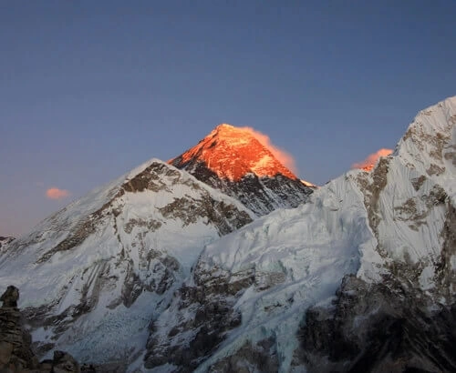
Early in the morning, we will wake up, have breakfast, and prepare for a trek to Kala Patthar, the world’s highest webcam. Kala Patthar, which lies at 5644 meters above sea level, is a perfect viewpoint for 360-degree views of the mountain peaks from the Mahalangur range.
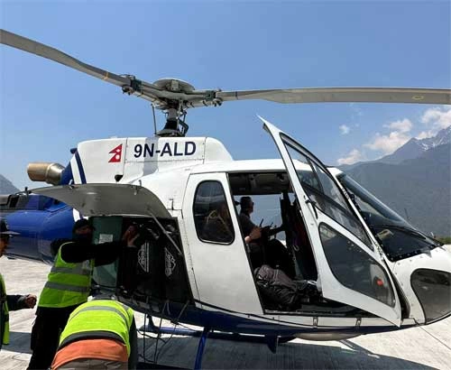
The wide-angle view of Mount Everest, Lhotse, Cho Oyu, and Ama Dablam is breathtaking, while the scenes of the Khumbu Glacier are worth your time. We will explore Kala Patthar and be involved in sightseeing activities before we head towards the Helicopter Pad for our return.
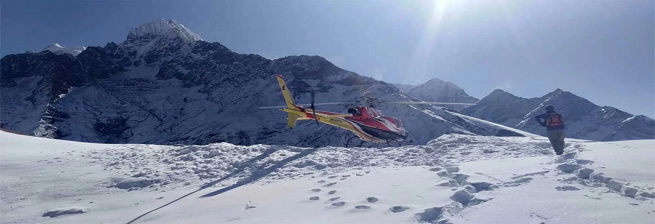
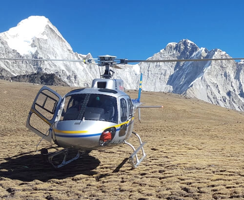
Helicopter return to Kathmandu is one of the best experiences ever. It offers the opportunity to have bird-eye views of the mighty Himalayas, Khumbu Glacier, traditional villages, and dense forests. After exploring the Everest region, we will fly back to Kathmandu and then return to our respective hotels for rest.
Day 12: Final departure
Our airport representative will provide transportation to Kathmandu Tribhuvan International Airport for your departure from Nepal.
Final Say
This page covers the Everest Base Camp trek with a helicopter return detailed Map and Itinerary . We've created a dedicated map and itinerary to improve your trekking experience. Our user-friendly map provides a clear overview of the journey with essential information. It's like having a compass for your trek, thanks to the detailed trail route it offers.
The map includes various graphical elements, such as icons with different shapes and colours, representing important features like International Boundaries, National Park Boundaries, Highways, Main Roads, Main Trekking Routes, Secondary Trekking Routes, Peaks, Temples, Monasteries, Chortens, Airports, Helipads, Glaciers, Rivers, Check Points, and more. Additionally, you can easily zoom in and out on the map by clicking the plus and minus buttons in the top-right corner.
The Everest Base Camp trek and Helicopter Return map and itinerary are a useful tool that provides accurate information about the key landmarks along the trekking trails in the Everest region. It's a valuable resource that makes navigating the challenging terrain of Everest much easier.
If you prefer a digital version, you can also get the map in PDF format, which is handy for tech-savvy trekkers who don't want to carry a physical copy.
With this map, you can estimate the total duration of your trip and plan your schedule. You can also determine the highest altitude you'll reach, the time required for the trek, and the overall distance you'll cover. In summary, the Everest Base Camp Trek By helicopter Return map is an essential resource to assist you during your trek.