Should you take a Manaslu trek map with you? Actually, the ability to read a map is extremely important up in the high mountains. Reading a map is one of the most basic and important hiking skills any Excursionist wants to include.
A trekker will often find this skill put to the test during a trek. This can be especially useful if you're hiking in remote or restricted regions of Nepal, like the Manalsu trek.
The Manaslu Circuit Trek is the most remote and exciting trek for every eager trekker. On this magnificent route, unexpected challenges await trekkers at every turn. Maps challenge you to think outside your box.
Excursions are all about expectation and planning, not the experience itself. For this reason, maps are also used extensively as a present to announce trips to distant places.
The Manaslu Trek is one of the top treks in Nepal. This 16-day voyage is a rare treat for off-the-beaten trekkers. Home to the world's eighth-highest peak is remarkable stuff all on its own. We are not surprised that you want to do the trek and have been looking for a Manaslu Trek Map.
The Manaslu Trek Map offers easy-to-follow directions to this ultimate off-the-beaten-path experience and exhalation of an ancient part of central Nepal far from other more popular treks encircling Mt. Manaslu. And Taking this map with you may be the best choice available.
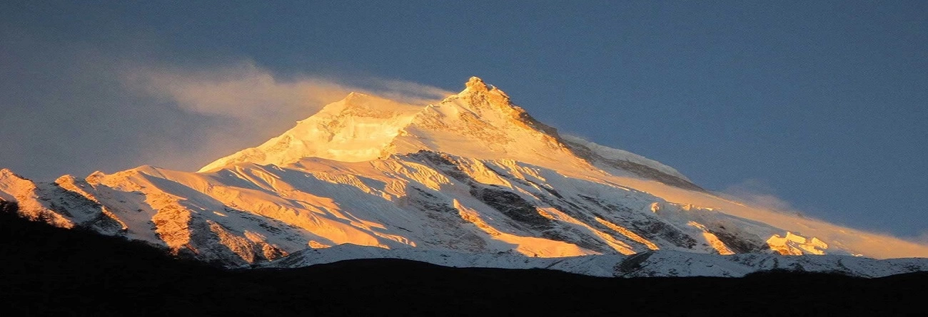
This exciting trail, aided by our Manalsu trek map, which takes the visitor into the more remote region of Manaslu circumscribed around Mt. Manalsu (8,163 meters), remains connected to its origins.
Its less crowded routes, the teahouses over moving through various terrains without common domestic flight time hassles, and economical pricing make it a lovely deal that you should roundly put on your list of Himalayan conquests. Although the Manaslu Circuit Trek visits wild, remote areas of the region, you can use tea houses with all their modern to basic facilities at each stage, making it easily approachable and economical.
But compared to Annapurna Circuit Trek, Manaslu is not very developed. Thus, checking the Manaslu Trek Map before setting out and along the way is important. Otherwise, it just gets too difficult to follow. Hence, we will invest a little time in this explanatory blog.
This is a read on the map for Manaslu Trek, also known as Manaslu Circuit Trek. So, we have both visual and educated forms of Manaslu Trek. After reading this blog, you will have more ideas about the Manaslu Trek.
Table of Contents
What Is Included in the Manaslu Trek Map?
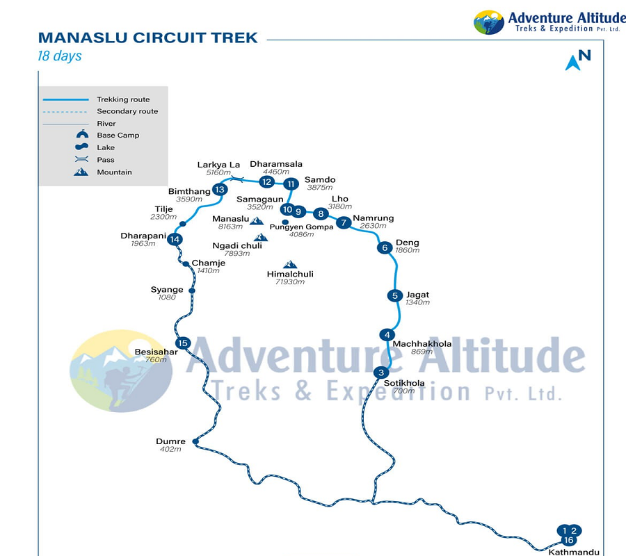
Manaslu Trek Map
This Manaslu Trek map shows everything a trekker needs to navigate the Manaslu trail. Major trekking paths are described in bold blue; secondary trails have a dotted line. Furthermore, there are straight lines that mark out the rivers you will encounter. Similarly, other symbols represent Lakes and passes, Base camps, or mountains. This map indicates the various terrains along a trekker's trail and will guide them through this remote and beautiful land. Here's a breakdown of what is included in the map:
1. Geographical Features:
The main trekking route is highlighted in bold blue.
Dotted blue lines represent secondary routes.
Straight lines indicate rivers encountered during the trek.
Markings for base camps, lakes, passes, and mountains.
2. Map Frame:
Acknowledgment of the border is enclosed in blue for orientation.
Color-coded Information:
Glaciers are addressed in blue letters.
Conservation areas are highlighted in Light letters.
The main trekking trail is depicted with a white dashed line enclosed in blue.
3. Landmarks and Stopping Points:
Popular landmarks and stopping points are labeled in highlighted-bold black letters.
Symbols for easy identification include peaks, campsites, temples, monasteries, World Heritage Sites, rivers, and bridges.
4. Additional Details:
Famous mountains and gompas like Ngadi Chuli (7893), Himalchuli (7193), Manaslu (8163 m), and Pungyen Gompa are represented by blue dots, etc.
Manaslu Trek Map- 15 Days Trekking Route
With this Manaslu Trek map, we wander through various vegetation types and traditional villages. The eighth-highest peak in the world, Manaslu (8163m), can be overwhelming. It's a very arduous trek. There's a lot of distance, and you must be in faraway places for two weeks.
That's what trekking is all about endurance and getting through tough times. Trekking reveals the true nature of an individual, and it is also peace itself. However, what to say about the benefits of trekking in the Himalayas--it doesn't need mentioning.
As for the trek map of Manaslu, this map is very straightforward and quite typical. You'll notice that there are a lot of Blue circle markers on the map. Some of them have numbers, and some don't.
The indicator is for major places and points. Thus, 1 represents the first day, and 16 represents the 16 days of the Manalsu trek on the chart. Our 16-day adventure in the region starts and ends in Kathmandu Valley.
Our route will be the Blue Trail. The accommodations and rest houses along this route are better. All the major trekkings begin and end in Kathmandu, just like this Manaslu circuit trek. We drive from Kathmandu to Macha Khola (900m) via Soti Khola (710 m). As our Manalsu trek map diagram all in blue shows, our trek office real trekking begins at Maccha Khola.
You can also see on the chart for this Manaslu Trek that we pass through Jagat (1410m), Deng ( 1920 m), Namrung(2700m), Lho(3180m), and Sama Gaun(3530m). The 9th day is spent hiking from Sama Gaun to the base camp below Manaslu (480Om), where we stay overnight. After a memorable acclimation hike, we trekked to Samdo (3780m) and (4480 m), then onto Bimthang at 37OOM via the fabulous Larkya La pass.
You will ascend Larkya La pass via the small path with both sides covered with snow. As you reach the pass, you will see many chortens hanging and a board which says " LARKE PASS (5106 m) WELCOME, To Manaslu Conservation Area, Wish You A Happy JOURNEY" all in bold letters.
After that, we will descend towards Dharapani, and the next day, we take a shared jeep ride via Besisahar and to Kathmandu.
Why Carry Manaslu Trek Map?
The Manaslu Trek map should definitely be on your packing list. Examining a map before setting off lets you understand the terrain in front and prepare for what's to come. For example, this trek includes reaching the trek's highest point, i.e., Larkya la Pass. If you are not carrying a map, you will not know how to reach this trek's highest point. Moreover, the well-crafted map can save your life. With an understanding of how to read a map, you can travel securely on that isolated trail from A to B while keeping your feet planted firmly on the ground.
Trekking on the wrong path is extremely dangerous. But venturing off the beaten track is dangerous, especially in a cold climate where losing your way is easy. Just have a good sense of direction and can read maps, then you will never get lost. Trekking can benefit you in many ways if your reading of maps isn't too bad.
In the high mountains, even small mistakes during trekking can be deadly. After that, when trekking, it's a big problem if something goes wrong. For example, your team turns against you, or one of the members disappears without a trace. You can help yourself and your fellow hiker friends rather than wait hours for assistance. Learning to read a map and use it while trekking may ultimately be what keeps you alive, as well as your teammates.
Locations are marked off on the trek map by differences in both elevation and distance. The walking path, villages, teahouses, lodges along the way, lakes, and halls are also described in greater detail.
How to Navigate Manaslu Route Using a Map?
It would help if you got acquainted with the environs around each point along your route before setting out for a walk. The Manaslu Trek map is no exception--first look at it and then start. To use a map to find your way, you need to be aware of the following:
Contour lines will help you better decide whether the trail requires ascending a mountain ridge or traversing an expansive forest. It also helps to calculate the gain in height of a difficult climb.
Compass edge: With a compass, you can determine how far your campground is from the trailhead.
Enlarge the map: If you find this map small and do not see the points and landmarks, double-click it and enlarge it. Moreover, for your convenience, there is an attached altitude map.
Detailed Itinerary for the Manaslu Trek
Day 1: Arrival at Kathmandu and transfer to your hotel
On the first day of the Manaslu Trek, we will welcome you to Tribhuvan International Airport. Our officials will ride you to Adventure Altitude's Office in Thamel, where you will have a meet-and-greet program. After that, you will be escorted to your hotel for rest.
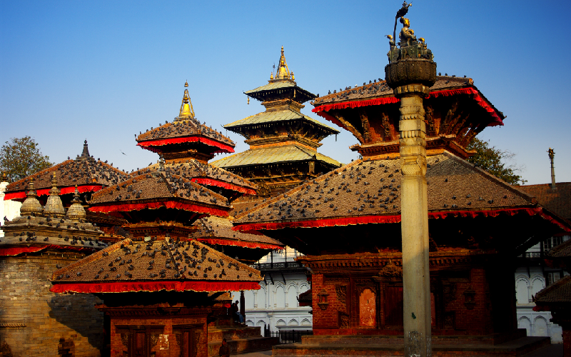
Day 2: Kathmandu Valley sightseeing and briefing day
Today, we will help you explore the major attractions in Kathmandu Valley. Starting our day with breakfast, we will head towards Pashupatinath Temple to learn Hindu culture and tradition insights.
Kathmandu Valley
From there, we will head towards Boudhanath and Swayambunath and get insights into Buddhist culture as well. Similarly, we will explore other attractions, such as Kathmandu Durbar Square and Narayanhiti Royal Palace (now a museum), to learn about the historical facts about Nepal.
After sightseeing around the Kathmandu Valley, we will return to our respective hotels and stay overnight.
Day 3: Drive From Kathmandu to Soti Khola and Machha Khola
Trek to Manaslu starts with a six-hour drive from Kathmandu. Traversing Prithivi Highway from the capital city and then through the terrace fields, green hills, and dense forest will take us to Arughat, one of the most exciting drives.
We will traverse the beautiful landscapes in Dhading, with the mountains and lush green forests constantly in sight. Then, from Arughat, we will embark on a trek to Soti Khola and then to Maccha Khola. Upon reaching Maccha Khola, we will stay at a teahouse.
Day 4: Trek to Jagat
Beginning the second day of the Manaslu Trek, we will leave Soti Khola after a warm breakfast. Today, we will reach Machha Khola, located among the greenfields and forest. It is a long walk, and one must take a few hours to reach that point. We will cross a suspension bridge over the Budi Gandaki River.
We will move through a rugged route to Khursani village to witness several beautiful waterfalls. After that, we will get to Labubesi and proceed to pass our way through rough land. It will take us a few hours of walking to reach Machha Khola.
Then, we will head towards Jagat from Machha Khola. Heading from Machha Khola, we catch a narrow path towards Tharo Khola. After crossing Tharo Khola, we will reach Kholar Besi and hike to Tato Pani (Natural Hot Spring). Later, we will get to the Budi Gandaki River and Doban by passing two suspension bridges.
From there, it only takes a few time to reach Jagat, where we will stay at a tea house.
Day 5: Trek to Deng- 07 hours
Now, leaving behind Jagat, we will head towards Deng, a village with an elevation of 2,130 meters above sea level. After leaving Jagat, we will hike through a deep gorge, and then there comes a steep valley, which we must descend downward.
This is the second time we have continued our journey toward the Budi Gandaki River. We must cross it again and catch the East Bank. We will find the trail that leads us down through the bamboo forest to Deng Khola. After that, we will finally arrive at Deng village, approximately 7 hours from Jagat.
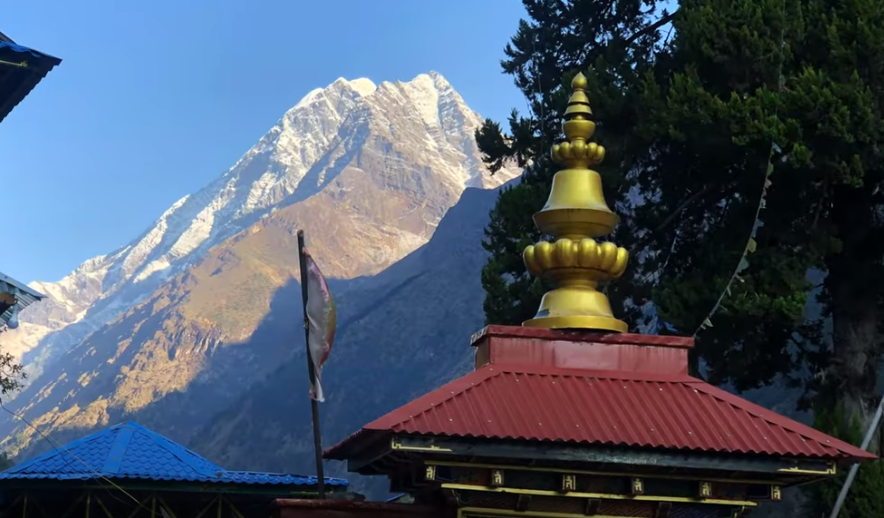
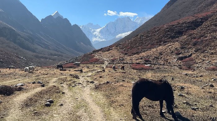
Day 6: Trek to Namrung
Namrung
Today, we will walk to Deng Village, around five to six hours from Deng. We must cross the Budi Gandaki River and go through a messy slope today. Then, we will go to Rana, where we will discover exciting trails leading to Budi Gandaki Valley's west side.
We will then proceed to Ghap Village through a Buddhist settlement, where ancient Buddhist culture flourishes all around the route. After that, we will go to the Prok Village and the gorge. Then, we will hike for the next few hours to get to Namrung. Throughout the trek, we will cherish the stunning views of the mountain peaks such as Ganesh Himal, Himal Chuli, and many others.
Day 7: Trek to Lho
On the sixth day, we will reach Lho Village, rich in Buddhist culture and tradition. We will start our day with a warm breakfast at Namrung Village, then hike through a steep hill and reach lush forests and green fields.
After a few hours of hike, we will first reach Lihi Village. From here, we can have the mirror reflection view of Mount Manaslu, which boosts our trek. From there, we will head towards Sho Village, passing through the Buddhist chortens and prayer flags. We will then ascend towards Lho Village at an altitude of 3,180 meters. Tonight, we will stay at a tea house.
Day 8: Trek to Samagaon
On the seventh day, we will reach Sama Gaon at 3530 meters above sea level. The estimated trek duration for today is around 5 hours. We will begin our journey from Lho to arrive at Samagaun in the afternoon.
We will head towards Shyala village and then trail to Sama. From there, the views of the magnificent Mount Manaslu and other surrounding peaks are visible. Likewise, the various glacier scenes are also some of the appealing views of this place.
There is also Ribung Monastery at Samagaun, which we can visit during our free time. Be respectful towards the Buddhist culture practiced for centuries in this region.
Day 9: Acclimatization day at Samagaon - full day
We must acclimate before trekking through the high altitudes above 3500 meters and reaching even higher heights. We will rest fully on the eighth day of the Manaslu Trek.
Since Samagaon lies 3530 meters above sea level, we must be fully prepared for the altitude. There is a high chance of suffering from altitude sickness and other related illnesses, including HACE (High Altitude Celebral Edema) and HAPE (High Altitude Pulmonary Edema). Trekkers can easily suffer from altitude sickness since the oxygen levels at high altitudes are very low.
Trekkers should eat nutritious food, focus on hydration, and rest enough to avoid altitude sickness and prioritize acclimatization. We also can visit monasteries and local habitats today.
Day 10: Trek to Samdo
Samdo
After acclimatizing at Samagaon, it's time to push our trek. We will reach Samdo Village today after a hike of around 5 hours. First, we will re-traverse the Budi Gandaki trail and arrive at the Larkya La.
After that, we will trek upstream through the stony gorge along the river, and finally, you will reach Samdo at 3860 meters above sea level. Make sure you are well-prepared for the high altitude of Samdo. Temperatures might be relatively low, so pack woolen outfits for the warmth.
Day 11: Trek to Dharmashala-
On the eleventh day of our trek, we will start our day with breakfast at Samdo and head towards Dharmasala. We will traverse some ancient Buddhist monasteries and settlements to reach our destination today.
Dharmasala lies 4480 meters above sea level, so you must be careful about the weather, temperature, and altitude. First, we will cross a bridge over the Budi Gandaki River and then head towards Larkya Glacier via Larkya Bazaar. Traversing the glacier will require technical climbing skills, but our trekking gear will help us.
We will finally arrive at Dharmashala after hiking for 6 hours, staying in a teahouse for the night.
Day 12: Trek to Bhimthang via Larkya La
We will walk to Larke Pass on the twelfth day and descend to Bimtang. Larke La Pass is one of the attractive tourist destinations in the region and sits at an altitude of 5213 meters above sea level. In the meantime, it is one of the most dangerous tourist destinations as the probability of suffering from altitude sickness is very high.
The journey to Larkya Pass is made through the sloppy terrain. And the magnificent views of the peaks like Annapurna, Kang Garu, and Himlung will soothe the journey. After we reach the pass, we will start descending to Bimtang. After several hours of walking, we will finally reach Bimtang.
Day 13: Trek to Dharapani
On the thirteenth day, we will start our trek from Bimtang, following a wide trail that will allow the beautiful sights from the Himofas to be seen. After a few hours, we will reach Dudh Khola, where we will cross a suspension bridge.
Afterward, we must climb upward through the forest and get to the bank of the Gho River. We will still struggle there as you climb to Tiliche (2560m).
From Tilche, we will continue hiking towards Dharapani. We must get to Thonje Village through Dudh Khola to reach today's destination. There is a police checkpost where we must show our license and permits for verification.
After a trek of almost 5 to 6 hours from Tilche, we will arrive at Dharapani. A waterfall called Tal is situated a little before Dharapani, which is very interesting.
Day 14: Drive from Dharapani to Kathmandu via Besisahar
From Dharapani, we will catch a bus to Besisahar first. t will take us through the bustling landscapes around the region, including the beauty of green forests, terraced fields, and ever-flowing rivers. e will reach Besisahar, the headquarters of Lamjung, within a few hours.
From Besisahar, we will take another bus to reach Kathmandu. It takes around 5 hours to reach the capital city from there. PAfter arriving in Kathmandu, we will move to our hotels overnight.
Day 15: Departure day
Today is the last day of this package. Ou will bid farewell to us and head to your home country. Your officials will help you to Tribhuvan International Airport, where you will board a flight to your country.
Manaslu Trek Map-Trekking Routes
We offer three different trekking itineraries for the Manalsu trek. Ll three manual trek packages Take ramblers into an untrammeled area near one of the world's top ten tallest mountain peaks. Below, we have already discussed the 16-day Manalsu trek. Now, let's learn about the other two Manalsu treks below.
Manaslu Tsum Valley Trek- 16 days
The Tsum Valley (Hidden Valley) area, at altitudes ranging from 1905 to 5093 meters, is home to many Tibetan people with their own culture, traditions, and ancient artifacts mostly untouched by modern civilization.
Travelers depart from Kathmandu and reach the hiking point of this 16-day journey, i.e., Maccha Khola. From Machha Khola, we locomote via the various famous places of the region like Doban, Philim, Chumling, Chhokangparo, Nile/Chgule, Mu Gompa, Rachen Gompa, etc.
In the east, Tsum Valley is enclosed by Boudha Himal and Himal Chuli; in its west are Ganesh Himal; and to the north, Siringa (7187m). The trail passes through two major villages of the region, Chumling (Lower Tsum) and Chhokangparo (Upper Tsum).
With the many Mani walls, chortens, and prayer flags along the route through a Tibetan Valley filled with Buddhist monuments, it offers some of the holiest of all monasteries in Tibet where Guru Rinpoche, as well as The eleventh-century philosopher Milarepa, once worshiped nearby. It is a place where the trekker can find oneself, and one finds peace of mind through meditation.
Manaslu Tsum Valley Trekking- 16 days
Day 1: Kathmandu Arrival
Day 2: Tsum Valley Restricted area trekking permit preparation and Kathmandu Tour
Day 3: Drive to Maccha Khola (869m) Via Soti Khola
Day 4: Trek Machha Khola to Doban
Day 5:bDoban to Philim
Day 6:Philim to Chumling
Day 7:Chumling to Chhokangparo ( Upper Tsum valley)
Day 8:Trek to Nile/Chgule
Day 9 On the route, pass the Piren Phu cave
Day 10:Rest day and explore around.
Day 11:Mu Gompa to Rachen Gompa
Day 12:Rachen Gompa to Dumje
Day 13:Dumje to Philim
Day 14:Philim to Tatopani
Day 15:Tatopani to Maccha Khola
Day 16:Drive to Kathmandu
Manaslu Tsum Valley Trek- 20 days
This is not a classic Manalsu adventure. Instead, the Manaslu trek map includes reaching and exploring the Tsuam Valley, also known as the Hidden Valley.
Much like the traditional trek map, you will track this route toward Machhakhola on a private jeep and make a short ascent hike up to Jagat on day 1. After passing through Deng, you will continue toward Lokpa (using this Manaslu Trek map), which also marks the end of examining vistas from the Ganesh Himal base camp at 3691 meters.
Next, you head towards the final village to enter Upper Tsum Valley--Nile- Chule. Then proceed to Mu Gompa, the biggest monastery of the Tsum Valley, and onward towards Rachen Gompa at 3240 meters above sea level. Having completed your Tsum Valley journey, you continue to descend to Chumling and then make contact with the classic Manaslu trail. Starting from here, you traverse the same trails as a traditional Manaslu Circuit Trek and reach Day 20, on which they return to Kathmandu by jeep. This combined trek allows you to visit the hidden valley and experience the highest point of this section of the route, Larkya La Pass.
Manaslu Tsum Valley Trek- 20 Days
Day 1:Drive From Kathmandu to Machha Khola
Day 2:Drive From Maccha Khola to Jagat
Day 3:Trek From Jagat to Lokpa
Day 4:Trek from Lokpa to Chumling
Day 5:Trek from Chumling to Chekampar
Day 6:Trek from Chekampar to Nile
Day 7:Acclimation Day- Day Trip to Mu Gompa
Day 8:Trek from Nile to Chekampar
Day 9:Trek from Chekampar to Chumling
Day 10:Trek from Chumling to Deng
Day 11:Trek from Deng to Namrung
Day 12:Trek from Namrung to Lho
Day 13:Trek from Lho to Sama Gaun
Day 14:Acclimatization Day (Day Trip to Manaslu Base Camp or Pungyen Gompa)
Day 15:Trek from Sama Gaun to Samdo
Day 16:Acclimatization Day (Day Trip to Tibet Border)
Day 17:Trek from Samdo to Dharamsala
Day 18:Trek from Dharmasala to Bimthang via Larkya Pass
Day 19:Trek from Bimthang to Dharapani
Day 20:Drive From Dharapani to Kathmandu
Manaslu Trek Map- Route Difficulty
Altitude Sickness
The maximum height we reach during the Manaslu Trek is 5,106 meters above sea level at Larkya La Pass. At such high altitude, trekkers are prone to health hazards like Acute Mountain Sickness (AMS), High Altitude Pulmonary Edema (HAPE), and High Altitude Cerebral Edema (HACE).
Preparing well for this possible hazard is particularly important for people not accustomed to high-altitude environments. It is recommended to carry a first aid kit and be careful to monitor one's physical condition. If any of the symptoms of altitude sickness occur, one should descend immediately to a lower altitude.
High Altitude
When planning a journey to Manaslu, trekkers must be prepared to expose themselves to high-altitude locations such as Larkya La Pass. If you are planning an off-season trek, it is far more dangerous than you can imagine.
Even during the peak trekking season, trekkers must be prepared for extremely low temperatures. Eather conditions in the Himalayas are unpredictable, pose significant risks, and temperatures may fall below freezing. To ensure safety and comfort, it is recommended to pack appropriate warm clothing and sleeping gear and have a means of heating water to maintain hydration and warmth.
Rugged And Steep Pathways
The dangerous terrain that must be passed to reach the Manaslu Region could form a serious stumbling block. However, near Pokhara and Besisahar, routes are not highly developed and can be quite rugged. Trekkers are recommended to pack the trekking gear properly and are encouraged to equip them with quality gear.
There's only one thing you must do if you plan a thrilling trek to Manaslu. I recommend adding two invaluable companions to your journey: a trekking guide and a porter. And their presence can transform your experience in different ways.
First off, safety is the main priority. Experienced guides are your first line of support, trained to handle emergencies such as altitude sickness and injuries. Besides, their familiarity with the terrain makes for easy navigation, preventing you from straying off the path.
Another valuable insight your guide has is local knowledge. They are acknowledged with the rich local culture, knowing the people, their customs, and hidden treasures inside out. Nand their suggestions for stunning scenery or logistics will add spice to your travels.
With a guide during the trek, it is as simple as crossing cultural bridges. They, speak the local language fluently and get special experiences. Take advantage of their knowledge and connections and experience cross-cultural activities.
Similarly, porters are also one of the integral parts of the journeys. They, help you lighten your load, and trekking becomes more fun. IBringing a porter relieves the weight of your backpack and gear.
Like guides, porters also serve as the local encyclopedia, with knowledge of the local landscapes, community, and culture.
So, as you embark on your next adventure, consider welcoming a guide and porter into your trekking family. Their expertise, support, and cultural insights will transform your journey, making it safer, richer, and an unforgettable experience.
Frequently Asked Questions
How Difficult Is The Trek?
Manaslu Trek is considered a moderate journey. However, the hike is challenging for some trekkers since the routes are rugged, and they have to walk for 6 to 7 hours daily.
How Long Does It Take To Reach The Destination?
It takes around 14 days to reach Manaslu Region and Larkya La Pass. The Trek includes your landing day in Kathmandu to your return day.
Is This Trek For Beginners?
Manaslu Trek is suitable for those who start trekking, aka beginners. If you can walk around 6 to 7 hours daily on rugged mountain routes, you can go on this Trek.
Which Is The Best Month To Go On The Trek?
The best months for going on this trek are March, April, September, and October.
What Are Manaslu Conservation Area Permits And ACAP Permits?
Manaslu Conservation Area Project (MCAP) Permits and ACAP (Annapurna Conservation Area Permits) are the entry permits required to enter the Manaslu and Annapurna Conservation Area. Ou need these entry tickets per the Nepal Tourism Board rules.
Where Can I Buy These Permits?
You can buy the required permits for Manaslu Trek at the Nepal Tourism Board Office in Kathmandu, Nepal.
Can I Trek To ABC Without A Guide?
No, you cannot. Now trekkers must compulsorily hire guides under the regulation of the Nepal Tourism Board.
Do You Get To See Snowfall During Trek?
If you are trekking in the winter, you will probably experience snowfall. Here in the region other seasons are usually normal and feature mild temperatures.
Final Say
The Manalsu circuit trek is one of Nepal's most spectacular Treks. This treks takes you to the foothills and the surroundings of the 8th tallest mountain, Manaslu Peak (part of the Mansiri Himalayan sub-range).
Despite being a restricted zone, it's a popular trekking region for foreign tourists and Nepalaese. for trekkers looking to lose themselves in nature and enjoy their own company, the combined Manaslu natural and remote trek would be worthwhile.
The Manaslu Trek map offers a much more practical way of trekking in the Himalayas. Take a map with you when planning an expedition in the faraway Himalayas. It helps you fight your way through difficult paths.
Elevation and trek distance can be counted on a map. Also, a map could be useful for escaping from there if you go astray. PIck up a Manaslu Trek Map and set out for this stunning vacation with us.
Hailing from the scenic expanse of Chitwan in Parsa, nestled adjacent to the enchanting Chitwan National Park, Mr. Rohit Subedi graces Adventure Altitude Treks as a seasoned Senior Accountant. Since his induction in 2018, immediately following the attainment of his master's degree, Rohit's journey has been marked by excellence. Elevating his role, our company entrusted him with the mantle of Tour Coordinator, specializing in crafting unparalleled journeys across Nepal, Tibet, and Bhutan.
.png)